Article 2. Rules of Construction, Abbreviations, & Definitions
In the event of differing language or numbering between the PDF and the web version of this text, the PDF version will control.
The text below and PDF linked above are reflective of the latest text amendments adopted by Charlotte City Council on Monday, June 16.
2.1 RULES OF CONSTRUCTION
For the purposes of these regulations, the following rules of construction shall apply:
- Conflicts
In the event of any conflict in standards applying to an individual use or structure, the more stringent or restrictive provision shall apply. - Illustrations, Diagrams, and Flowcharts
Illustrations, diagrams, and flowcharts are included in this Ordinance to illustrate the intent and requirements of the text. In the case of a conflict between the text and any illustration, diagram, or flowchart, the text shall control. - Tables and Matrices
Unless otherwise specifically indicated, a cell within a table or matrix that is blank and shaded denotes that the standard does not apply. - Days
Unless otherwise specifically indicated in this Ordinance, days are calculated as follows:- When a period of time is specified in days, such period of time shall be computed in calendar days.
- In computing any specified period of time from a specified event, the day on which the event happens is deemed the day from which an act is authorized or required to be done.
- If the period is of two days, Saturday, Sunday, or a public holiday is excluded if it is an intervening day between the day when an act is authorized or required to be done and the last day of the period.
- Fractions
Any fraction of a half or more shall be rounded up to nearest whole number, and a fraction of less than a half will be rounded down to the nearest whole number, unless how such fraction is treated is specifically indicated in an Ordinance regulation. - Mandatory, Permissive, and Prohibiting Terms
- The terms “shall,” “must,” and “will” are mandatory, indicating an obligation to comply with the particular provision.
- The terms “may,” “should,” “encouraged,” and “can” are permissive, indicating that compliance with a particular provision is not mandatory but allowed.
- The terms “shall not,” “must not,” “will not,” “cannot,” and “may not” are prohibiting, indicating an action or other provision is prohibited.
- Lists
Unless otherwise expressly indicated, lists of items or examples that use “including,” “such as,” or similar terms are intended to provide examples only and shall not be construed as being limited to the items or examples listed. - Conjunctions
- “And” indicates that all connected words or provisions apply.
- “Or” indicates that the connected words or provisions may apply singly or in any combination.
- “Either […] or” indicates that the connected words or provisions apply singly, but not in combination, referring to a choice between options.
- General Construction
- The present tense includes the past and future tenses, and the future tense includes the present.
- The singular includes the plural and vice versa.
- Words denoting one gender apply to all genders.
- Terms Not Defined
Whenever a defined word or term appears in the text of this Ordinance, its meaning shall be construed as set forth in the definition. Words not defined shall be interpreted in accordance with the definitions considered to be normal dictionary usage.
2.2 GENERAL ABBREVIATIONS
The following abbreviations may be used within this Ordinance. Additional abbreviations may be used throughout this Ordinance.
BTZ is an abbreviation for “build-to zone.”
GFA is an abbreviation for “gross floor area.”
ft is an abbreviation for “feet.”
N/A is an abbreviation for “not applicable.”
NR is an abbreviation for “nonresidential.”
sf (lowercase) is an abbreviation for “square feet.”
ETJ is an abbreviation for “extraterritorial jurisdiction.”
SF (capitalized) is an abbreviation for “single-family.”
MDD is an abbreviation for “multi-dwelling development”
MF is an abbreviation for “multi-family.”
MF-A is an abbreviation for “multi-family attached.”
MF-S is an abbreviation for “multi-family stacked.”
2.3 GENERAL DEFINITIONS
The terms used in this Ordinance are defined as follows, unless otherwise specifically indicated in this Ordinance. Article-specific definitions include: 1) definitions of uses listed within the Global Use Matrix in Article 15, found in Section 15.3; and 2) article-specific definitions are found within select articles in Part IX, Stormwater. In the case of a conflict between a term defined in this section, and that within Article 15 or an article in Part IX, Stormwater, the definition within those specific articles control.
Abutting. Having common property boundaries or lot lines which are not separated by a street.
Accelerated Erosion. Any increase over the rate of natural erosion as a result of land disturbing activity.
Access Management. Strategies associated with driveway plan approval that seek to link operational and access characteristics of each site to the public street system, by aligning access type, the number of driveways, and driveway spacing to land use, the site’s geography, and street type.
Access Restrictions. Any restrictions to less than full vehicular movement at an access point, often as a condition of a driveway plan approval.
Accessibility Ramp. A ramp or similar structure that provides access to a building for wheelchairs and other mobility aids.
Accessory Structure. A structure located on the same site as the principal building that is incidental and subordinate to the function of the principal building.
Active Use. A use listed in the Residential Uses category of the Use Matrix and nonresidential uses listed in the Commercial Uses category, the Industrial Uses category, and/or the Institutional and Governmental Uses category of the Use Matrix in Article 15.
Adequate Erosion Control Measures, Structures, or Devices. Measures, structures, or devices that control the soil material within the land area under responsible control of the person conducting the land disturbing activity.
Adjacent. Having common property boundaries or lot lines, or located directly across a street, alley, railroad, other transportation corridor, or body of water 100 feet or less in width.
Adjoining. See “Adjacent.”
Administrative Decision. Decisions made in the implementation, administration, or enforcement of development regulations that involve the determination of facts and the application of objective standards set forth in the development regulations.
Affiliate. A person that directly or indirectly through one or more intermediaries, controls, is controlled by, or is under common control of another person.
Alley. A private or public right-of-way or easement which runs between two or more lots or located on a single lot, affording primary or secondary vehicular access to the properties which abut it, but not including a street, utility easement, or railroad right-of-way.
Alteration (of a Structure). A change, addition, or modification in construction, other than cosmetic or decorative, or any change in the structural members of buildings such as bearing walls, columns, beams, or girders.
Alteration (of a Watercourse). A dam, impoundment, channel relocation, change in channel alignment, channelization, or change in cross-sectional area of the channel or the channel capacity, or any other form of modification associated with development which may increase the FEMA or Community Base Flood Elevations.
Alternative Compliance Review Board (ACRB). The Alternative Compliance Review Board is an appointed, quasi-judicial citizen board that primarily considers requests for alternative compliance to select standards for the applicable zoning districts.
Amateur (ham) Radio Equipment. An amateur (ham) radio station licensed by the Federal Communications Commission (FCC), including equipment such as, but not limited to, a tower or building-mounted structure supporting a radiating antenna platform and other equipment.
Amenitized Tree Area. An area that serves to meet green area requirements and includes planted trees and amenities, such as irrigation, landscaping, grass, seating, pathways, lighting, or other items, as approved by the Chief Urban Forester.
Amenity Zone. Hardscaped area located between the back of curb and the sidewalk or shared use path. Amenity zones include, but are not limited to, perimeter trees, landscaping, and street furnishings.
Appeal. An appeal is a process where parties request a higher authority to review an administrative decision or quasi-judicial decision in order to modify or reverse the decision.
Arcade. A succession of contiguous arches, each supported by columns or piers, designed to provide a sheltered walkway for pedestrians.
Architectural Feature. A part or projection of a structure that contributes to the overall aesthetics of the building, excluding signs, that is not necessary for the structural integrity of the structure or to make the structure habitable.
Area Median Income (AMI). The midpoint of a region’s income distribution with half of the households earning more than the AMI and half earning less. Household income is calculated by its gross income.
Average Grade. The average grade is determined by measuring the grade at the outermost corners of each elevation of the structure and calculating the average. Alternatively, average grade may be determined by measuring the grade at intervals of five feet or less around the perimeter of the structure and calculating the average.
Average Grade

Awning. A roof like structure typically made of cloth, metal, or other material attached to a frame that extends from and is supported by a building. Awnings are typically erected over a window, doorway, or building front, and may be raised or retracted to a position adjacent to the building.
Balcony. A roofed or unroofed platform that projects from the exterior wall of a structure, above grade, which is exposed to the open air, has direct access to the interior of the building, is surrounded by a parapet, railing, or balustrade, and is not supported by posts or columns extending to the ground.
Banner. A temporary sign printed upon flexible material mounted with or without rigid frames.
Bay Window. A window that projects outward from the structure, which does not rest on the building foundation or on the ground.
Belt Course. A continuous row or layer of stones or brick set in a wall that makes the horizontal line of the sills visually more prominent. A belt course is also called a string course or sill course.
Berm. An earthen mound designed to provide visual interest on a site, fully or partially screen undesirable views, reduce noise, and/or fulfill other similar purposes.
Bicycle Facilities. Any infrastructure and/or physical provisions to accommodate or encourage bicycling, including, but not limited to, parking and storage facilities, on-street facilities such as bicycle lanes, variously configured buffered/separated bicycle lanes, shared-use paths along streets, and shared off-street public paths.
Bicycle Parking Space. An area occupied by a bicycle when using a bicycle parking device as designed.
- Bicycle Parking Spaces, Long-Term. Bicycle parking spaces where bicycles will be stored for longer periods of time within a weatherproof storage area.
- Bicycle Parking Spaces, Short-Term. Bicycle parking spaces available to visitors to the site where bicycles are stored for short stops, requiring a high degree of convenient access.
Billboard. See “Outdoor Advertising Sign” under “Off-Premise Advertising.”
Blank Wall, Ground Floor. The horizontal linear dimension of contiguous building wall that does not contain windows, doors, or decorative elements such as banding, medallions, artwork such as murals and mosaics, change in wall plane of at least three inches, or other architectural or material embellishment. Any wall less than five feet in height is not considered to be a blank wall.
BLANK WALL, GROUND FLOOR

Blank Wall, Upper Floor. The horizontal or vertical linear dimension of contiguous building wall that does not contain windows, doors, or decorative elements such as banding, medallions, artwork such as murals and mosaics, change in wall plane of at least three inches, or other architectural or material embellishment. A wall does not count as a blank wall as long as one of the dimensions of the wall area is less than the maximum blank wall area standard of the district.
BLANK WALL, UPPER FLOOR

Block. A tract of land bounded by streets, or a combination of streets (network-required and public) and railroad rights-of-way or municipal boundary lines.
Block

Blockface. Blockface is measured as that portion of a block or tract of land facing the same side of a single street and lying between the closest intersecting streets, railroad rights-of-way, or municipal boundary lines.
BLOCKFACE

Block Length. The distance along a block between two adjacent intersections, measured from centerline to centerline.
Board of Adjustment, UDO. The UDO Board of Adjustment is an appointed, quasi-judicial citizen board that primarily considers appeals, variances, and requests for interpretation of the Unified Development Ordinance.
Borrow. Fill material that is required for on-site construction and is obtained from other locations.
Breezeway. An unenclosed and roofed outdoor passage connecting two buildings, such as a dwelling and garage.
Build-To Percentage. The percentage of the building facade that shall be located within the build-to zone (BTZ), calculated by building facade, not lot width. Build-to percentage is further defined as:
- Facade articulation elements, such as window or wall recesses and projections, shall be considered to meet any required build-to percentage.
- Public open spaces and outdoor dining areas that are between a building facade and a frontage and are no more than an average of 24 inches above or below grade of adjacent sidewalk are counted as meeting the build-to percentage.
- Common or private open spaces of residential development bounded on three sides by a building and no more than an average of 24 inches above or below grade of adjacent sidewalk are counted as meeting the build-to percentage.
BUILD-TO PERCENTAGE

Build-To Zone (BTZ). A build-to zone (BTZ) is the area on a lot, measured parallel from the required frontage setback line, where the minimum build-to percentage of a structure shall be located. A build-to zone sets a minimum and maximum dimension within which the building facade line shall be located per the requirements of the minimum build-to percentage.
BUILD-TO-ZONE (BTZ)

Building. Any structure having a roof supported by columns or walls used or intended for supporting or sheltering any use or occupancy.
Building Coverage. The portion(s) of a lot developed with principal buildings and accessory buildings.
Building Façade. The exterior wall of a building
Building Height. Building height is the vertical distance between the average grade at the base of the structure and the highest point of the structure. The following shall not be included in the measurement of building height:
- Any structures integral to the operation of the use, such as smokestacks, chimneys, cooling towers, water towers, elevator houses, mechanical stacks, and similar features.
- Firewalls, chimneys, sky lights, and roof structures for elevators, stairways, tanks, heating, ventilation and air-conditioning equipment, or similar equipment for the operation and maintenance of a building and any device no more than five feet in height used to screen around a roof top structure or equipment.
- Parapet walls of five feet in height or less are not included in the maximum building height calculation. When parapet walls exceed five feet in height, the parapet wall is included in the maximum building height calculation.
BUILDING HEIGHT

Building Length. Building length is measured as the length of the facade abutting a frontage. Passageways, breezeways, ground floor passages and similar building connections are included in the calculation of total building length.
- Building Length, Maximum. The maximum length of a building allowed along a frontage, established either by a set amount of linear feet or a percentage of lot width.
- Building Length, Minimum. The minimum length a building shall be along a frontage, established either by a set amount of linear feet or a percentage of lot width.
BUILDING LENGTH

MINIMUM BUILDING LENGTH

Building Line. A line that is tangent to the building’s facade that is parallel to the front, side, and/or rear lot lines.
BUILDING LINE

Building Site. An area of land or property where development is undertaken.
Built-Upon Area (BUA). That portion of a property that is covered by impervious or partially impervious surface including, but not limited to: buildings; pavement and gravel areas; and recreation facilities such as tennis courts (activity fields that have been designed to enhance displacement of runoff, such as compaction and grading or installation of sodded turf, and underground drainage systems for public parks and schools will be considered built-upon area.) Built-upon area does not include a wooden slatted deck or the water area of a swimming pool.
Built-Upon Area (BUA) Density. The total built-upon area divided by the total project area as further defined in the Stormwater Control Measure (SCM) Design Manual.
Bus Route/Bus Transit Route. Specifically labeled or numbered travel routes over which a Charlotte Area Transit Service (CATS) bus operates for the purpose of picking up or dropping off passengers at regularly scheduled stops and intervals.
Caliper. The diameter measurement of the trunk taken six inches above ground level for trees up to and including four-inch caliper size. Measurement shall be taken 12 inches above the ground level for larger trees.
Canopy. A canopy is a roof-like cover designed for protection from the weather or as a decorative embellishment affixed to a building or freestanding, with supports that extend to the ground.
Carport. An open-sided roofed vehicle shelter, typically formed by extension of the roof from the side of a building, but may also be freestanding.
Certificate of Occupancy. A document issued by Mecklenburg County Code Enforcement, a division of the Mecklenburg County Land Use and Environmental Services Agency, to provide official verification that the declared scope of work permitted is in compliance with current building and land development regulations, and the building is suitable for occupancy.
Certiorari. Certiorari is a form of judicial review where a superior court is asked to hear an appeal of a quasi-judicial decision of a decision-making board, such as the UDO Board of Adjustment.
Chamfered. Building design where the corner or right-angled edge is cut away to make a sloping symmetrical edge.
Change of Use. A change of use is the change of the use of a structure or lot from one major land use category to another, such as commercial to residential use. Major land use categories are established in the Use Matrix in Article 15.
Changeable Copy. That portion of a sign that allows for a message to be changed.
Charging Station. A parking space intended for electric vehicles and served by vehicle battery charging equipment.
Charlotte Area Transit System Director (CATS Director). The Charlotte Area Transit System (CATS) Director, which may include their designee, in administration of the Ordinance.
Charlotte Department of Transportation Director (CDOT Director). The Charlotte Department of Transportation (CDOT) Director, which may include their designee, in administration of the Ordinance.
Charlotte Streets Map. The most recently adopted map showing Charlotte’s collector and arterial street network, and limited access roads. It also shows any local streets that include the Cross Charlotte Trail (XCLT) or other Urban Trail. The Charlotte Streets Map describes the expected future cross-section for each arterial street in the network.
Charlotte Tree Manual. The most recently updated guidelines that support the implementation of tree protection, planting, and preservation requirements of this Ordinance as contained in Section 4.1 of the UDO Zoning Administration Manual.
City Attorney. The City Attorney or their designee.
City Tree. All planted trees in the street right-of-way and any naturally occurring trees three inches diameter in breast height (DBH) or greater in street right-of-way as specified in Section 4.1 of the UDO Zoning Administration Manual. For the purposes of this term, street right-of-way includes all segments of City-accepted and/or City Landscape Management-maintained public street rights-of-way (Charlotte Department of Transportation (CDOT) or North Carolina Department of Transportation (NCDOT)) in Charlotte’s corporate city limits. Landscape Management maintains trees on NCDOT street right-of-way in the city limits except for road segments identified in Section 4.1 of the UDO Zoning Administration Manual.
Civil Judicial Remedies. The means with which a civil court of law imposes a penalty or makes another court order to address a specific case involving a violation.
Colonnade. A sequence of columns either freestanding or part of a building, typically as pairs or multiple pairs of columns, that frames a walkway or open space, which may be covered or open to the air.
Commercial Vehicles, Large. Any vehicle, including trailers, designed or used for business purposes that has a gross vehicle weight rating (GVWR) of 13,000 pounds or more. Large vehicles also include commercial vehicles with a GVWR of less than 13,000 pounds if the height of the vehicle exceeds 9.5 feet, including any installed accessories such as ladder racks, cranes, compressors, hose reels, welders, etc., or the length of the cargo area/work platform exceeds 14 feet, not to include step bumpers less than 18 inches in length.
Commercial Vehicles, Light. Any vehicle designed or used for business purposes that has a gross vehicle weight rating (GVWR) of less than 13,000 pounds and a cargo area/work platform, including any installed accessories such as ladder racks, cranes, compressors, hose reels, welders, etc., that does not exceed the height of the cab of the vehicle. Cargo area/work platforms separate from the cab shall not exceed nine feet in length not to include step bumpers less than 18 inches in length. A pickup truck, sport utility vehicle, van, or similar vehicle may be considered a passenger vehicle if it is less than 13,000 pounds GVWR and has only the original showroom stock body/bed. A camper shell, toolbox within the bed, or similar accessory equipment will not disqualify the vehicle as a passenger vehicle. However, ladder racks, cranes, compressors, hose reels, welders, and similar equipment make the vehicle a commercial vehicle.
Commercial Vehicles, Medium. Any vehicle designed or used for business purposes that has a gross vehicle weight rating (GVWR) of less than 13,000 pounds and does not exceed 9.5 feet in height, including any installed accessories such as ladder racks, cranes, compressors, hose reels, welders, etc. Cargo area/work platform shall not exceed 14 feet in length, not to include step bumpers less than 18 inches in length.
Completion of Construction or Development. No further land disturbing activity is required on a phase of a project except that which is necessary for establishing a permanent groundcover.
Comprehensive Plan. The most recent Comprehensive Plan that has been officially adopted by the City pursuant to N.C.G.S. § 160D-501.
Comprehensive Transportation Review (CTR). An analysis that measures the multimodal transportation impacts created by a development and proposes transportation mitigations necessary to support the proposed development.
Connectivity. Street or subdivision design which provides for public access, ingress, and egress within a development and with adjoining developments by one or more of the following: interconnecting streets, bike paths, and walkways. Connectivity facilitates vehicular, bicycle, and pedestrian transportation.
Conservation Agreement Area. An area that is subject to a conservation agreement that places a restriction, reservation, easement, covenant, or condition, in any deed, will, or other instrument executed by or on behalf of Mecklenburg County, the City of Charlotte, or a conservation group as approved by the Chief Urban Forester, pursuant to the Section 4.1 of the UDO Zoning Administration Manual. Such agreement shall be appropriate to retain land or water areas predominantly in their natural, scenic, or open condition. This term includes County designated nature preserves, Tree Canopy Preservation Program (TCPP) properties, or conservation easements held by approved land conservation groups.
Conservation Protection Area. The land set aside for required green area and common open space in a conservation residential development
Contractor Conducting the Land Disturbing Activity. Any person who participates in the land disturbing activity, including, but not limited to, the general contractor and subcontractors with the responsibility for supervising the work on the tract for the changing of the natural cover or topography of the tract or any part thereof.
Cornice. A horizontal decorative molding that crowns a building.
Cottage Court Residential Development. Small lot residential development of various dwelling types organized around a common open space, designed as a cohesive whole and maintained in shared stewardship by residents.
Courtyard. Open space, other than a required setback, unoccupied except by obstructions permitted in setbacks, on the same lot with a building, which is bounded on two or more sides by the walls of such building.
Critical Area. The area adjacent to a water supply intake or reservoir where risk associated with pollution is greater than from the remaining portions of the watershed.
Critical Root Zone. The area of soil around the tree where roots that provide stability and uptake of water and minerals are located, the main structural and functional part of the root system. It is a protected circular area around a tree with a radius equal to one foot per inch of tree diameter at breast height (DBH) with the tree trunk at the center of the circle.
Cross-Access. A means of providing vehicular and pedestrian access between two or more properties, or between two or more sites located on one property. Cross-access may be provided by easement, drive aisle, alley, or service drive, and is separate from the public street system.
CROSS-ACCESS

Cul-De-Sac. A street designed with a turnaround, such as but not limited to, a bulb or hammerhead design. A stub street, as defined in this Article, is not considered a cul-de-sac.
CUL-DE-SAC (BULB DESIGN)

Daily Vehicular Trips. The total number of ingress and egress vehicle trips generated within a 24-hour weekday period by a land use or private development, per latest ITE Trip Generation Manual.
DBH (Diameter at Breast Height). The diameter of a tree 4.5 feet above the average ground level
Deck. A roofless outdoor space built as an above ground platform projecting from the wall of a structure and connected by structural supports at grade and/or by the structure.
Dedication. Dedication is the conveyance of private land, either in fee simple or as an easement, for public use.
Density. The number of dwelling units per gross acres.
Determination. A written, final, and binding order, requirement, or determination regarding an administrative decision.
Developer. A person, including a governmental agency or redevelopment authority, who undertakes any development and who is the property owner of land to be developed or who has been authorized by the property owner to undertake development on that property.
Development. Any of the following: a) the construction, erection, alteration, enlargement, renovation, substantial repair, or movement to another site, or demolition of any structure; b) the excavation, grading, filling, clearing, or alteration of land; or c) the subdivision of land as defined in N.C.G.S. § 160D-802.
- Development, Accessory. Development as defined above of a land use listed in the Accessory Uses category of the Use Matrix in Article 15.
- Development, Campus. Development as defined above of a land use listed in the Campus Uses category of the Use Matrix in Article 15.
- Development, Commercial. Development as defined above of a land use listed in the Commercial Uses category of the Use Matrix in Article 15.
- Development, Industrial. Development as defined above of a land use listed in the Industrial Uses category of the Use Matrix in Article 15.
- Development, Infrastructure. Development as defined above of a land use listed in the Infrastructure category of the Use Matrix in Article 15.
- Development, Institutional and Governmental. Development as defined above of a land use listed in the Institutional and Governmental Uses category of the Use Matrix in Article 15.
- Development, Mixed-Use. Development as defined above of a project with a residential component listed in the Residential Uses category and a nonresidential component listed in another principal use category of the Use Matrix in Article 15.
- Development, Open Space, Recreation, and Agricultural. Development as defined above of a land use listed in the Open Space, Recreation, and Agricultural Uses category of the Use Matrix in Article 15.
- Development, Public Health and Social Service. Development as defined above of a land use listed in the Public Health and Social Service Uses category of the Use Matrix in Article 15.
- Development, Residential. Development as defined above of a land use listed in the Residential Uses category of the Use Matrix in Article 15.
- Development, Temporary. Development as defined above of a land use listed in the Temporary Uses category of the Use Matrix in Article 15.
- Development, Transportation. Development as defined above of a land use listed in the Transportation Uses category of the Use Matrix in Article 15.
Development Approval. An administrative or quasi-judicial approval that is written and that is required prior to commencing development or undertaking a specific activity, project, or development proposal. Development approvals include, but are not limited to, zoning permits, site plan approvals, variances, and certificates of appropriateness. The term also includes all other regulatory approvals required by regulations in the Ordinance, including subdivision plat approvals, permits issued, development agreements entered into, and building permits issued.
Development Regulation. A Unified Development Ordinance, zoning regulation, subdivision regulation, soil erosion and sedimentation control regulation, floodplain regulations, post-construction control regulation, water supply watershed regulation, drainage regulation, surface water improvement and management buffer regulations, tree regulations, historic district regulations, or any other regulation in the Ordinance that regulates land use and development.
Director of Stormwater Services. The Director of Stormwater Services or their duly authorized representatives.
Discharge. The addition of any man induced waste effluent either directly or indirectly to North Carolina surface waters.
Discharge Point. That point at which concentrated flow of discharge leaves a tract of land.
Disturbance. Any use of the land by any person or entity which results in a change in the natural cover or topography of the land.
DNL (Day Night Average Sound Level). A noise metric used to reflect a person’s cumulative exposure to sound over a 24-hour period. DNL accounts for both the amount of noise from each aircraft operation as well as the total number of operations flying throughout the day and applies an additional 10dB weighting for nighttime flights between 10 p.m. and 7 a.m.
Dock. A fixed or floating structure, including moorings, used for the purpose of berthing buoyant vessels.
Down-Zoning. To reclassify a parcel of land through a zoning map amendment process by decreasing the intensity of the development of the land to be less intense than was allowed under the previous zoning district category, or reducing the permitted uses of the land to fewer uses than were allowed under its previous usage.
Donation Box. An unmanned receptacle designed with a door, slot, or similar opening intended to accept and store donated clothes and household items.
Drainage Area. That area of land that drains to a common point on a project site.
Drainage Basin. The area of land which drains to a given point on a body of water.
Drip Line. A vertical line running through the outermost portions of the tree crown extending to the ground.
Drive-Through Lane. An on-site driveway approach to a building opening, including windows or mechanical devices, where customers initiate and complete their transaction.
Dwelling. A structure, or portion thereof, designed or used for human habitation.
Dwelling Unit. A single unit providing complete, independent living facilities for no more than one family, including permanent provisions for living, sleeping, eating, cooking, and sanitation.
Easement. Authorization by an owner for the use, by others for a specific purpose, of a designated part of their property.
Eave. The projecting lower edges of a roof overhanging the wall of a structure.
Electric Vehicle (EV) Charging Stations. Electric vehicle (EV) charging stations are defined as follows:
- EV-Capable: Reservation of space in the electrical room for a panel to serve the future EV chargers and continuous raceway from the reserved panel space to the future EV parking space.
- EV-Ready: Installation of electrical panel capacity and raceway with conduit to terminate in a junction box or 240-volt outlet accessible to parking space.
- EVSE-Installed: EV charging stations capable of providing a minimum of 32amp 7.2 kW.
Energy Dissipater. A structure or a shaped channel section with mechanical armoring placed at the outlet of pipes or conduits to receive and break down the energy from high velocity flow.
Erosion. The wearing away of land surface by the action of wind, water, gravity, or any combination thereof.
Establishment. A place of business.
Evidentiary Hearing. A hearing to gather competent, material, and substantial evidence in order to make findings for a quasi-judicial decision required by a development regulation.
Existing Tree Canopy. Tree canopy that has existed for at least two years prior to development as evidenced by City or County aerial photographs, or a tree survey of trees one-inch caliper and larger.
Expansion (of a Building). An increase in the floor area of a building. This may also be referred to as an addition to an existing building.
Expansion (of a Use). An increase in the area dedicated to the use.
Expansion (of a Structure). An increase in the size of a structure.
Exterior Lighting. The illumination of an outside area or object by any man-made device that produces light by any means.
Exterior Stairway. One or more flights of stairs, and the necessary landings and platforms connecting them, to an entryway on another floor or level in a structure located on the exterior of a principal building.
EXTERIOR STAIRWAY

Extraterritorial Jurisdiction (ETJ). The authority of the City to apply its zoning regulations outside of the City boundaries.
Façade. The exterior wall of a building.
Façade Modulation. Variations in the plane of a building facade that break up the mass and bulk of a building. The modulation is the recessed or projected portion, of the building facade and/or architectural feature as distinguished from the building facade line.
Familial Relationship. A close familial relationship means a spouse, parent, child, brother, sister, grandparent, or grandchild. The term includes the step, half, and in-law relationships.
Family. An individual or two or more persons related by blood, marriage, domestic partnership, adoption, foster child relationship, or legal guardianship together as a single housekeeping unit. Family also includes a group of not more than six persons not related by blood, marriage, domestic partnership, adoption, foster child relationship, or legal guardianship, living together as a single housekeeping unit.
Feather Flag. A freestanding attention-getting device typically constructed of cloth held taut by a single post. Also known as a sail.
Fence. A structure used as a boundary, screen, separation, means of privacy, protection, or confinement.
- Fence, Solid. A fence that has, over its entirety, no distributed openings. A shadowbox design fence is considered a solid fence. A chain link fence with slats is not considered a solid fence.
Flag. Fabric containing an emblem or message designed to be flown from a flagpole which may be either freestanding or a mast arm flagpole that extends at an angle from a building.
- Flag, Commercial. Flags designed to direct attention to or promote a business, product, service, event, or activity occurring on the site, which are flown from a mast arm flagpole.
- Flag, Noncommercial. Flags that do not function to direct attention to or promote a business, product, service, event, or activity.
Flag Lot. See “Lot.”
Flashing Lighting. Lighting that changes from a static intensity of illumination, through fading, pulsing, and/or other method, at a frequency of more than once every thirty seconds.
Floodlight/Spotlight. A powerful light or a grouping of several lights used to illuminate the exterior of a building or sign.
Floodplain. The land subject to inundation by the community base flood and is encompassed by the community special flood hazard area.
Floor. See “Story.”
Footcandle. A unit of illuminance or illumination, equivalent to the illumination produced by a source of one candle at a distance of one foot and equal to one lumen incident per square foot.
Forest Practice Guidelines. The written directions related to water quality prepared by the North Carolina Department of Agriculture and Consumer Services Division of Forest Resources and the United States Forest Service, including, but not limited to, the Forestry Best Management Practices Manual prepared by the North Carolina Department of Agriculture and Consumer Services.
Formal Affiliation. A relationship between a service provider and the primary institution of the campus the service provider serves and supports. A formal affiliation shall be evidenced by the physical integration of the service provider into the building(s) of the primary institution of the campus and/or by a written agreement between the service provider and the primary institution of the campus.
Freight Rail. A railroad corridor or railroad right-of-way used to transport freight. Such corridor or right-of- way may also be used by intercity passenger railroad service. Freight rail does not include local rapid transit rail service. Freight rail is not considered a frontage.
Frontage. A frontage is that part of the lot that faces either: 1) an existing or Ordinance required public or network-required private street; 2) a street designated on the Charlotte Streets Map; 3) a platted right-of-way offered for dedication and at least 30 feet in width; or 4) a public space, such as a publicly owned open space, public path, or transit corridor.
- Frontage, 2-3 Lane Avenue. Frontage that includes the following street classifications: 2 lane avenue, 2+ lane avenue, or 3 lane avenue, as defined by the associated Avenue street classification definition.
- Frontage, 4-5 Lane Avenue/Boulevard. Frontage that includes the following street classifications: 4 lane avenue, 4+ lane avenue, 5 lane avenue, 5+ lane avenue, 4+ lane boulevard, 5+ lane boulevard, as defined by the associated Avenue or Boulevard street classification definitions.
- Frontage, 6 Lane Avenue/Boulevard. Frontage that includes the following street classifications: 6 lane avenue, 6+ lane avenue, 6+ lane boulevard, 6+ or more lane boulevard, as defined by the associated Avenue or Boulevard street classification definition.
- Frontage, Main Street. Frontage for property fronting on a Main Street, as defined by the Main Street classification definition.
- Frontage, Other-Primary. Frontage for property fronting on a collector street, a transit station, a public or network-required private local street abutting a Neighborhood 1 Place Type, or a public park or other publicly owned open space, or an off-street public path.
- Frontage, Secondary. A frontage that is not designated in items 1 through 5 above or items 7 through 12 below, and includes public and network-required private local streets.
- Frontage, Parkway. Frontage for property fronting on a Parkway, as defined by the Parkway street classification definition.
- Frontage, Limited Access. Frontage for property fronting on a Limited Access Road, as defined by the Limited Access Road street classification definition.
- Frontage, Uptown Signature Street. Frontage for a property fronting an Uptown Signature Street, as defined by the Uptown Signature Street classification definition.
- Frontage, Uptown Primary Street. Frontage for a property fronting an Uptown Primary Street, as defined by the Uptown Primary Street classification definition.
- Frontage, Uptown Secondary Street. Frontage for a property fronting an Uptown Secondary Street, as defined by the Uptown Secondary Street classification definition.
- Frontage, Linear Park. Frontage for a property fronting Linear Park, as defined by the Linear Park Street classification definition.
Full Pond Elevation. Elevation at which water begins to flow over the dam or spillway for the lake, referenced to mean sea level as determined by the United States Geological Survey (U.S.G.S.) Datum. The applicable full pond elevations are as follows: Mountain Island Lake at 647.5 feet and Lake Wylie and Lower Lake Wylie at 569.4.
Future Back of Curb. The future back of curb shall be based on the Charlotte Streets Map for Main Streets, Avenues, Boulevards, and Uptown streets as well as local and collector streets with shared-use paths. The future back of curb location for all other local and collector streets is the location of the existing back of curb, unless otherwise specified by this Ordinance. For streets not indicated on the Charlotte Streets Map that also have a ditch or swale instead of curb and gutter, the top of backslope is considered future back of curb.
Garage. An accessory building or portion of a principal building designed to be used for the storage of motor vehicles and other household items of the occupants of the premises.
Gallery. A platform which projects from the exterior wall of a building, is exposed to the open air, and remains unenclosed, that has direct access to the interior of the building. A gallery is supported from the ground by columns or poles, and is surrounded by a parapet, railing, or balustrade.
Grade. The finished ground elevation at a specific point on a site.
Grading. Excavation or fill of material, including the resulting conditions thereof.
Green Area. An area and all affiliated vegetation, whether on-site or off-site, which is set aside, conserved, or dedicated, pursuant to the requirements of Section 20.15.
Green Roof. A vegetated area of a roof of a structure that is designed and planted to be covered at maturity by plants. Green roofs shall be subject to the specifications and standards of specific articles of the Ordinance when it is proposed to meet the requirements of those articles.
Green Terrace. A vegetated area on a horizontal surface of a structure that is lower in elevation than the roof and is designed and planted to be covered at maturity by plants.
Green Wall. A wall covered with live plants, which includes a growing medium, such as soil, water, or a substrate. A green wall is also called a living wall or vertical garden.
Green Zone. The space lying between the sidewalk and back of curb, or edge of pavement where no curb-andgutter is present (typically a planting strip or hardscaped amenity zone) which serves as a buffer between pedestrians and vehicles. The green zone typically includes street trees and landscaping, and often includes street furnishings and utilities.
Greenway. A corridor of predominantly vegetated land preserved for bicycle and pedestrian travel and recreational use, including multi-use trails, such as the Cross Charlotte Trail. A designated greenway is one that is designated in the Mecklenburg County Greenways and Trails Master Plan. Greenways are not considered a public park (as the use is defined in Article 15).
Gross Floor Area (GFA). The gross floor area (GFA) of a structure is the sum of the gross horizontal areas of all floors of the structure as measured from the exterior faces of the exterior walls or from the centerline of walls separating two buildings. GFA does not include any areas used exclusively for surface parking lots or parking structures, or for building or equipment access, such as stairs, elevator shafts, and maintenance crawlspace. Active use space within a parking structure counts toward GFA.
Groundcover. Any low-growing plants that protect topsoil from erosion and drought conditions, and help to conceal bare earth and prevent weed growth.
Ground Floor. The floor of a building along a frontage that is nearest the level of the ground. Where a change in elevation results in a new floor corresponding to the ground level along a frontage, such new portion of the building is also considered a ground floor.
Ground Floor Activation. A ground floor is considered activated when uses from the following use categories of the Use Matrix in Article 15 are located on the ground floor adjacent to pedestrian accessible pathways and vehicle roadways: Residential Uses category, Commercial Uses category, the Industrial Uses category, and/or the Institutional and Governmental Uses category.
Guard Station. A structure used to house personnel and security equipment, typically located at an entryway to a development.
Half Street. See “Partial Street”.
Hazardous Material. Any substance listed as such in: 40 CFR 302, Extremely Hazardous Substances, CERCLA Hazardous Substances, or Section 311 of Clean Water Act (oil and hazardous substances).
Hazardous Tree. A tree that presents a situation or condition that may result in personal injury, property damage, or disruption of human activities. Also:
- In tree management, a tree or tree part that has a high likelihood of failure and causing damage or injury; and
- In tree care or forestry operations, the presence of a condition or situation that may cause harm or injury to workers or others.
Hedge Row. A row of closely planted shrubs, bushes, or any kind of plant forming a boundary.
Heritage Tree. Any tree native to North Carolina per the US Department of Agriculture Natural Resource Conservation Service Plants Database with a DBH of 30 inches or greater.
I-277 Loop. The area of the city situated inside the boundaries of interstate highways 277 and 77.
Illumination, External Sign. Lighting of a sign from a light source external to the body of the sign, so that light is directed on to the face of the sign or directed in a manner so as to create silhouettes of letters or symbols that are placed in front of the light.
Illumination, Internal Sign. Lighting of a sign from internal sources, such as a light source within the framework of a sign cabinet and behind the face of the sign so that light is transmitted through the face of the sign.
Impervious Surface. Any structure or material that prevents, impedes, or slows infiltration or absorption of water directly into the ground. This includes, but not limited to, buildings; pavement and gravel areas such as roads, parking lots, and paths; and recreation facilities such as tennis courts (activity fields that have been designed to enhance displacement of runoff, such as compaction and grading or installation of sodded turf, and underground drainage systems for public parks and schools will be considered built-upon area). Impervious surface does not include a wooden slatted deck or the water area of a swimming pool.
Impervious Surface Coverage. Impervious surface coverage is a measure of intensity of land use that represents the portion of a site that is occupied by impervious surfaces. Maximum impervious surface of a lot is calculated as the percentage of all impervious surface area against the total area of the lot.
Inert Debris. Solid waste consisting solely of material that is virtually inert, that is likely to retain its physical and chemical structure under expected conditions of disposal, and that will not pose a threat to groundwater standards. Inert debris includes material such as concrete, brick, concrete block, uncontaminated soil, rock, and gravel.
Infill. The development of vacant or under-used parcels within areas that are already largely developed.
Internal Planting Area. A planting area located on private property outside the public right-of-way.
Invasive Plant Species. Any shall be any species listed in the North Carolina Invasive Plant Council list of invasive species.
Land Conservation Group. A nonprofit land trust or similar organization approved by the City as listed in Section 4.1 of the UDO Zoning Administration Manual that permanently protects land, water, trees and wildlife habitat to enhance quality of life in Charlotte and Mecklenburg County.
Land Development Approval. Final approval of development projects submitted to the City, including, but not limited to: 1) commercial, subdivision, and/or urban-zoned projects; or 2) plats, both singularly or related to the aforementioned projects.
Land Disturbing Activity. Any use of the land by any person in residential, governmental, industrial, educational, institutional, or commercial development, highway and road construction and maintenance that results in a change in the groundcover or topography and that may cause or contribute to sedimentation.
Landscape Yard. Land area with landscape plantings and other components used to separate one use or development from another and/or to shield or block noise, lights, or other nuisances.
Large Maturing Shade Tree. Any tree the height of which is 35 feet or greater at maturity and has a limb spread of 30 feet or more at maturity.
Large Waste Container. A dumpster, compactor, open-top container, and detachable container that is used for collecting, storing, or transporting solid waste. A large waste container is picked up by a specially equipped truck for transporting the waste materials to the disposal site.
Larger Common Plan of Development or Sale. Any contiguous area where multiple separate and distinct construction or land disturbing activities will occur under one plan. A plan is any announcement or piece of documentation including, but not limited to, public notice or hearing, drawing, permit application, zoning request, or site design or physical demarcation, including but not limited to, boundary signs, lot stakes, or surveyor markings, indicating that construction activities may occur on a specific plot.
Legislative Decision. A decision by the City Council after a legislative hearing regarding the adoption, amendment, or repeal of an Ordinance regulation or a zoning map amendment.
Legislative Hearing. A public hearing to solicit public comment on a proposed legislative decision.
Light Pole Banner. Banners mounted on and with arms installed perpendicular to a light pole.
Lighting, Full Cut Off. A light distribution where the candela value is zero at or above horizontal (90°above nadir) and does not exceed 10% at or above a vertical angle of 80°above nadir.
Lighting, Semi Cut Off. A light distribution where the candela value does not exceed 5% of the maximum intensity at or above horizontal (90°above nadir) and 20% at or above a vertical angle of 80°above nadir.
Lighting, Full Cut Off; Lighting, Semi Cut Off

Loading Space. An unobstructed area, not located within the public right-of-way, maintained for the temporary parking of trucks and other delivery vehicles for the purpose of loading and unloading goods, wares, materials, and merchandise.
Lot. Any quantity of land and/or water capable of being described in definitive terms with respect to its location and boundaries, which have been established through some legal instrument such as a recorded deed or map. A lot may be established as distinct from other lots which are designated by its owner or developer as land to be used or developed as a unit, or which has been used or developed as a unit. Lots are also referred to as parcels. The following defines the types of lot configurations:
- Interior Lot. A lot other than a corner or through lot, bounded by two interior side lot lines.
- Corner Lot. A lot situated at the junction of, and abutting on, two or more intersecting streets.
- Through Lot. A lot which fronts upon two parallel streets, or which fronts upon two streets which do not intersect at the boundaries of the lot. A through lot is also called a double frontage lot or reverse frontage lot.
- Corner Through Lot. A lot which fronts upon three streets of which two streets do not intersect at the boundaries of the lot.
- Flag Lot. A lot which meets minimum lot width requirements, but which contains a main building site area (the “flag”) separated from the frontage by an access strip (the “pole”). Any lot which narrows to a dimension of less than 50% of the lot width at any point between a street and the front building line shall be considered a flag lot. The creation of new flag lots is prohibited (Section 16.1.C).
LOT TYPES

FLAG LOT

Lot Area. The total area within the boundaries of a lot, excluding any street or railroad right-of-way, usually defined in square footage. For lots located on an existing publicly maintained street that do not have any record of right-of-way dedication, the lot area is the total area within the boundaries of the lot minus the area within the maintained street.
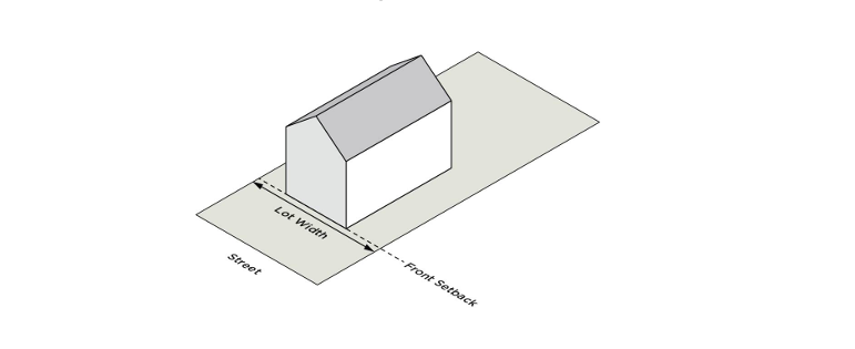
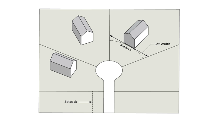
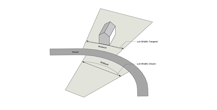
Lot Width. The distance between the side lot lines measured along the front setback line as established by this Ordinance, unless one of the following conditions apply:
LOT WIDTH
- For cul-de-sac lots, along the turnaround portion of a cul-de-sac street, the distance between the side lot lines measured along a setback line shown on a duly recorded plat when the setback line on the plat is greater than the setback required by this Ordinance; or..
LOT WIDTH ALTERNATIVE (ITEM 1)
- On lots located on the outside curve of a street, the lot width shall be measured along a line tangent to the midpoint of the setback projected to the side lot lines. On lots located on the inside curve of a street, the lot width shall be measured along the chord of the setback arc where it intersects the side lot lines.
LOT WIDTH ALTERNATIVE (ITEM 2)
Lot Line. A line dividing one lot from another lot or from a street or alley.
Low Impact Development (LID). The integration of site ecology and environmental goals and requirements into all phases of urban planning and design from the individual residential lot level to the entire watershed.
Luminaire. A complete lighting unit for the purpose of generating usable and controllable light that is comprised of one or more lamps, parts designed to distribute the light, parts used to position and protect the light source, and a means to connect the light source(s) to an electrical supply.
Manufactured Home Stand. The area of a manufactured home site that has been reserved for the placement of a manufactured home.
Marquee. A permanent roof-like structure constructed of permanent building materials that extends from the wall of a structure with no supports extending to the ground providing protection from the elements.
Mass. The size or physical bulk of a building.
Master Plan. A long-term plan that provides a conceptual layout to guide future growth and development.
Mean Sea Level. The National Geodetic Vertical Datum (NGVD) of 1929, or other datum, to which base flood elevations shown on the Flood Insurance Rate Maps for Mecklenburg County are referenced.
Mechanical Equipment. Equipment related to the operation of a structure, such as, but not limited to, heating, ventilation, and air conditioning (HVAC) equipment, personal electrical generators, and swimming pool pumps and filters. Mechanical equipment does not include accessory utility equipment.
Mixed-Use Building. A building that contains both nonresidential and residential uses.
Modular Home. A method of construction for residential dwellings. Modular homes are built in multiple sections, called modules, at a facility and then delivered to the site where the modules are set onto the building’s foundation and joined together to make a single building. Modular buildings and modular homes shall conform to all zoning requirements for the dwelling type and shall meet all local and state residential building code requirements.
Mullion. A vertical or horizontal element that forms a division between units of a window or screen or is used decoratively. When dividing adjacent window units, its primary purpose is a rigid support to the glazing of the window.
Multi-Tenant Nonresidential Development. A development under unified control that contains multiple separate businesses, offices, light manufacturing facilities, and research uses, and may include accessory and supporting uses, that is designed, planned, and constructed on an integrated and coordinated basis. Examples include, but are not limited to, research parks, office parks, industrial parks, or a combination of such uses.
Multi-Use Development. A development site of more than one building that contains a mix of nonresidential and residential buildings, some or all of which may be mixed-use buildings as well.
Multi-Use Path. A pathway serving both pedestrians and bicyclists located in an independent off-street alignment.
Nadir (Lighting). The angle pointing directly downward from the luminaire.
NCDOT. North Carolina Department of Transportation.
Nit. A unit of measurement of the intensity of visible light, where one nit is equal to one candela per square meter.
Noise Exposure Map (NEM). A map that shows aircraft noise levels surrounding an airport prepared in accordance with 14 CFR PART 150 and reviewed by the Federal Aviation Administration (FAA).
Noncommercial Message. Messages and emblems that do not function to direct attention to or promote a business, product, service, event, or activity, either on-site or off-site. Examples of noncommercial messages include, but are not limited to, signs advocating a public issue, recommending a candidate for office, and personal messages.
Nonconforming Lot. Any lawfully existing lot on the effective date (June 1, 2023) of these regulations, or any subsequent amendment thereto, which does not meet the minimum area or width requirements established by these regulations.
Nonconforming Sign. Any lawfully existing sign on the effective date (June 1, 2023) of these regulations, or any subsequent amendment thereto, which does not comply with the Ordinance regulations.
Nonconforming Structure. Any lawfully existing structure on the effective date (June 1, 2023) of these regulations, or any subsequent amendment thereto, which does not comply with the Ordinance regulations.
Nonconforming Use. Any lawfully existing use of a building, structure, or land on the effective date (June 1, 2023) of these regulations, or any subsequent amendment thereto, which does not comply with the Ordinance regulations.
Non-Point Source (NPS) Pollution. Forms of pollution caused by sediment, nutrients, organic and toxic substances originating from land use activities and carried to lakes and streams by surface runoff.
Nonresidential Development. All development other than residential development, agriculture, and silviculture.
Off-Street Public Path. A pathway typically shared by pedestrians and bicyclists which is located outside of the street right-of-way, but within a public right-of-way or easement, including, as applied in this Ordinance, greenways, transit trails, off-street trail connections, and bicycle and pedestrian connections.
Off-Street Trail Connections. A publicly accessible trail connection from a public or network-required private street to a park or off-street public path.
Open Space. Land and water areas designed and reserved for use as active or passive recreation areas. Pedestrian connections and passages are not considered open space unless they are an integral part of an open space area.
- Open Space, Common. Open space maintained for the shared use of the residents and/or tenants of the development.
- Open Space, Public. Open space maintained for, and freely accessible to, the use of the general public. Public open space may include parks, plazas, and public seating areas.
- Open Space, Private. Open space reserved for the sole use of the resident of the associated dwelling unit and/or tenant of the associated tenant space.
Paper Street. A right-of-way, no less than 30 feet in width, for a street offered for dedication on a final recorded plat which has not been constructed or accepted by the city for maintenance.
Parapet. The extension of the main wall or walls of a building above the roof level. Also called a parapet wall.
Parcel. See “Lot.”
Parkway. Streets with the primary function of moving large volumes of motor vehicles efficiently from one part of the city to another. They are designed to serve high traffic volumes at relatively high speeds and typically have very limited direct access to land uses.
Partial Street. A street that lies along a property line between two properties and is partially improved on only one of the properties at a time.
Passenger Vehicle. Any vehicle designed to transport passengers that does not otherwise meet the definitions of Large Commercial Vehicle, Light Commercial Vehicle, or Medium Commercial Vehicle of this ordinance.
Patio. A hard surface that adjoins a principal structure designed and intended for dining or recreation and not used as a parking space. Patios are constructed such that its finished walking surface is laid or poured directly on finished grade.
Pedestrian. Anyone who travels on foot as well as those with disabilities who require assistive devices.
Pedestrian and Bicycle Connection. A paved shared-use facility connecting a cul-de-sac to a street, off-street public path, or park.
Pedestrian Facilities. Sidewalks, shared use paths, and similar facilities intended for pedestrian mobility.
Pennant. Any lightweight plastic, fabric, or other material, whether or not containing a message of any kind, suspended from a rope, wire, or string, usually in series, designed to move in the wind. Streamers are considered pennants.
Permanent Enclosed Area. An area that is structurally enclosed by a solid floor constructed of subfloor and foundation, ceiling, and solid walls, which may have partitions and/or windows.
Person(s). An individual, partnership, firm, association, joint venture, public or private corporation, trust, estate, commission, board, public or private institution, utility, cooperative, interstate body, the State of North Carolina and its agencies and political subdivisions, or other legal entity.
Phase of Grading. One of two types of grading: rough or fine.
Place Types. Place Types are a classification system that provides guidance on the land uses, transportation characteristics, and building form that is appropriate for an area, as set forth in the Comprehensive Plan. The most recently adopted Policy Map assigns a Place Type designation to specific geographies and each property in the City’s jurisdiction as a translation of the Comprehensive Plan’s place-based policies.
Planning Commission. The Charlotte-Mecklenburg Planning Commission, including any duly appointed committee of that body provided for and authorized to act for the whole Planning Commission by the Interlocal Cooperation Agreement of July 2, 1984, as may be amended.
Planning Director. The Director of Charlotte Planning, Design, and Development Department, which may include their designee in administration of the Ordinance.
Planting Area. Ground surface free of built upon area and/or paved material which is reserved for required tree planting.
Planting Strip. Ground surface free of built upon area and/or paved material, located between the back of curb and the sidewalk or shared use path. Planting strips typically include perimeter trees and other plantings.
Policy Map. The most recently adopted map that assigns a Place Type designation to each property in the City’s jurisdiction. The Policy Map is a translation of the Comprehensive Plan’s place-based policies to specific geographies and each property in the City’s jurisdiction
Porch. An architectural feature that projects from the exterior wall of a structure and is covered by a roof or eaves.
- Porch, Enclosed. A porch enclosed by walls, screens, lattice, or other material. A screened-in porch is an enclosed porch.
- Porch, Unenclosed. A porch that is open on all sides excluding those sides that abut a principal building wall.
Portable Sign Structure. A sign structure that is intended, by design and construction, to rest upon and/or be supported by the ground and can be moved and reused. Portable sign structures include, but are not limited to, signs mounted upon a trailer, wheeled carrier, or other non-motorized mobile structure, with wheels or without wheels. Portable sign structures do not include A-frame or temporary off-premises advertising signs.
Porte Cochere. A permanent structure built over a driveway or entry drive that provides shelter to persons exiting a vehicle.
Prescribed Conditions. Standards for a principal, accessory, or temporary use, typically used to mitigate impacts of such use on adjacent areas.
Principal Building or Structure. A building or structure containing the primary use of the lot.
Primary Pedestrian Entrance. The main public entrance to a building for commercial, industrial, mixed-use, public, and institutional uses. For residential buildings, the primary pedestrian entrance is the front door. For multi-family buildings in which each unit does not have its own exterior entrance, the primary pedestrian entrance may be a lobby, courtyard, etc.
Private Entity. Any entity other than a local, state, federal, or other unit of government.
Prominent Entrance. A building entrance that is visually distinctive from the remaining portions of the facade where it is located and is parallel and directly connected to adjacent pedestrian facilities. A prominent entrance must be a pedestrian-only entrance. Emergency egress doors and doors to mechanical rooms or stairwells are not considered a prominent entrance.
- For nonresidential, mixed-use, and multi-family stacked units, entrances that contain at least three of the following are considered a prominent entrance: decorative pedestrian lighting/sconces; architectural details carried through to upper stories; covered porches, canopies, awnings, or sunshades; archways; transom or sidelight windows; terraced or raised planters; common outdoor seating enhanced with specialty details, paving, landscaping, or water features; double doors; stoops or stairs.
- For multi-family attached units, entrances that contain one or more of the following features are considered a prominent entrance: porches, raised steps and stoops with or without roof overhangs, decorative railings.
PROMINENT ENTRANCE

Property. All real property subject to land-use regulation by the City and County. The term includes any improvements or structures customarily regarded as a part of real property.
Property Owner, Landowner, or Owner. The holder of the title in fee simple. Absent evidence to the contrary, a local government may rely on the Mecklenburg County tax abstract to determine who is a property owner.
Protected Area. The area adjoining and upstream of the Critical Areas of water supply watersheds where risk of water quality degradation from pollution, while still greater than non-watershed designated areas, is less than in the Critical Areas.
Public Path. A constructed pathway used for recreation and pedestrian and/or bicycle traffic. A public path includes a transit trail, a shared used path, and a greenway trail.
Quasi-Judicial Decision. A decision involving the finding of facts regarding a specific application of a development regulation and that requires the exercise of discretion when applying the standards of the regulation.
Rapid Transit Corridor. A typically linear area that is reserved for rapid transit infrastructure.
Rapid Transit Station. The designated stations where passengers embark and disembark along a rapid rail line or a bus rapid transit stop.
Recycling Station. The area designated for the collection and temporary storage of recyclables.
Reservation. The process of reserving land for the potential use by the City, County, or other agency for streets, transit lines, greenways, or other public facilities.
Retail and Shipping Service Lockers. A secure, self-service kiosk, not regulated by the USPS, for customers to receive packages.
Retail Center. A commercial development under unified control consisting of three or more separate retail goods establishments, personal service establishments, restaurants/bars, offices, and amusement facilities, that is designed, planned, and constructed on an integrated and coordinated basis. Also called a shopping center.
Reuse. The occupancy of a pre-existing structure for an active use. Reuse may include the rehabilitation or modification of an existing structure to serve the needs of a new use.
Right-of-Way. the area on, below, and above an existing or proposed public roadway, highway, street, bicycle lane, sidewalk, or similar facility, and associated adjacent land that is dedicated or otherwise legally established for public use.
Roofline. The highest point of a flat roof and mansard roof, and the lowest point of a pitched roof, excluding any cupolas, chimneys, or other minor projections.
Satellite Dish. A dish antenna designed for transmitting signals to a receiver or receiving station or for receiving television, radio, data, communication, or other signals from other antennas, satellites, or other services.
Screening. A fence, wall, hedge, landscaping, earth berm, buffer area or any combination of these provided to create a visual and/or physical separation between certain land uses. Screening may be located on the property line or elsewhere on the site.
Searchlight. An attention-getting device where an artificial light of high intensity is shined upward in a focused beam and can turn in any direction to attract attention to a location. Also known as sky-beams or sky spotlights
Security Gate(s). Gates located at the entry to a lot or development, where access is controlled by automatic gate openers, a manned guard station, or similar means.
Sediment. Solid particulate matter, both mineral and organic, that has been or is being transported by water, air, gravity, or ice from its site of origin.
Sedimentation. The process by which sediment resulting from accelerated erosion has been or is being transported off the site of the land disturbing activity or into a wetland, lake, or watercourse.
Separation. When principal uses are required to be measured a certain distance from another use or district, the distance measured, in a straight line, from the nearest point of the lot line on which such principal use is proposed to be located to the nearest point on the lot line where the other use or district is located, unless otherwise specifically required to be measured differently by this Ordinance.
Septic System. A ground absorption sewage disposal system consisting of a holding or settling tank and a ground absorption field.
Setback. The minimum dimension a structure may be located as measured from a curb line, lot line, right-of-way line, or other point set by the Ordinance, along frontages and side and rear lot lines. A setback shall be located at or behind the required pedestrian/bicycle facilities and planting strip/amenity zone.
- A front setback is a required setback located along the shortest lot line dividing the lot from the right-of-way.
- For flag lots, the front setback is measured from the rear lot line of the lot that separates the flag portion of the lot from the street.
- A rear setback is a required setback located opposite and/or farthest from a front setback along the rear lot line dividing the lot from another lot.
- A rear setback may be measured as a radius from the furthest property corner from the frontage in either of the following conditions:
- The lot is an interior lot that is triangular.
- One side of the lot has an interior angle of at least 135 degrees and acts as an extension of the side setback.
- A rear setback may be measured as a radius from the furthest property corner from the frontage in either of the following conditions:
- A side setback is a required setback located along an interior side lot line(s) that divides the lot from another lot.
- A corner side setback is a required setback located along the longest lot line dividing the lot from the right-of-way.
- On a through lot, where required setbacks are not established by a frontage, both setbacks along a street shall be considered front setbacks.
- On a corner through lot, where required setbacks are not established by a frontage, the front setback requirement for the district shall be applied to the two opposing street fronts and the third street front shall be considered a corner side setback.
- Measurement of setbacks shall be as follows:
- The setback on frontages is measured from the future back of curb at the outermost point from the centerline, right-of-way line, or as otherwise specified by this Ordinance.
- The setback on non-street frontages (transit stations, off-street public paths, public parks, and other publicly-owned open spaces) shall be measured from a property line or right-of-way line.
- If the frontages on a corner lot are the same length, the Zoning Administrator may determine the front and corner side setback.
Setback, Established. An established setback is the area between the curb line, lot line, or other point set by the Ordinance and the building line of a principal building or structure. The established setback includes the required setback.
ESTABLISHED SETBACK

Setback, Required. See “Setback.”
SETBACK

SETBACK – THROUGH LOT

Setback Line. See “Setback.”
Service Area. Those areas on a site reserved for building services, such as solid waste and recycling storage and collection areas and loading docks.
Shadowbox. Shadowbox design within display windows, where the window display is designed with a background enclosure against which signs are mounted to block views into the establishment, is considered a window sign and the entire area of the shadowbox is subject to the maximum sign area limitation.
Shared-Use Path. A pathway serving both pedestrians and bicyclists located along a street, between the curb and adjacent development.
Shopping Center. A development greater than 50,000 square feet in gross floor area consisting of a group of two or more establishments, such as but not limited to retail goods establishments, restaurants/bars, commercial fitness centers, etc., which has been planned, constructed, and developed with a coordinated approach to buildings and associated outparcels, parking areas, and service areas.
Sidewall. A wall that forms the side of a structure. Sidewalls are measured from the finished floor elevation of the main floor to the eave or, if no eave is present on the structure, to the bottom of the finished roof plane.
Sidewalk. An improved pedestrian facility located within public right of way, an easement, or on private property. Public sidewalks located along a street are typically separated from the street by a planting strip or amenity zone.
Sight Distance. The length of street visible to the driver who is traveling along the street or waiting to enter or cross the street.
Sign. A structure, device, or object using words, letters, figures, designs, emblems, symbols, fixtures, colors, illumination, and/or projected images. The terms below are types of signs referenced in the sign regulations.
- Sign, A-Frame. A temporary sign ordinarily in the shape of the letter “A” or some variation thereof, which is displayed on the ground, not permanently attached to the ground, and usually two-sided, generally connected at the top and separated at the bottom.
- Sign, Accessory Use. A sign for a use which is customarily or typically subordinate to and serving a principal use.
- Sign, Animated. A sign that uses moving or changing lights to depict action, movement, or the optical illusion of movement of part of the sign structure, sign, or pictorial segment, or including the movement of any illumination or the flashing or varying of light intensity to create a special effect or scene.
- Sign, Awning. A sign printed or displayed upon an awning.
- Sign, Balloon. A sign or advertising device designed to be airborne or inflated and tethered to the ground or other structure. This includes any air-inflated signs and any signs that inflate and move via air inflation.
- Sign, Canopy. A sign printed or displayed upon a canopy.
- Sign, Decorative. A pictorial representation, including illustrations, words, numbers, or decorations; emblem; flag; banner; pennant, that promotes or celebrates the city, its neighborhoods, civic institutions, or public activities or events in the city. Decorative signs may either be designed and displayed by the city directly or may be donated to the city on a permanent basis or for a limited period of time.
- Sign, Drive-Through. A ground sign constructed along drive-through lanes for drive-through facilities. A drive-through sign does not include parking lot, parking structure, and site circulation signs.
- Sign, Electronic. A sign designed where a portion of the sign area uses changing light emitting diodes (LEDs), fiber optics, light bulbs, or other illumination devices within the electronic display panel to display a message or messages in text and/or image from where the sequence of messages and the rate of change is electronically programmed and can be modified by electronic processes. Time/temperature signs are not considered electronic message signs. Electronic outdoor advertising signs are not considered electronic signs and are regulated separately.
- Sign, Flashing. A sign with an intermittent or sequential flashing light source used primarily to attract attention. Flashing signs do not include electronic signs or video display screens.
- Sign, Government. Any temporary or permanent sign erected by and maintained for any governmental purposes.
- Sign, Ground. A sign that is placed on and/or supported by the ground, independent of a structure on the lot.
- Sign, Historic. A historically significant sign, as designated by the criteria and process of Section 22.11.D, that has been moved from its original location to be reused on another site to promote the protection of nonconforming signs that represent important aspects of the City’s heritage, to enhance the character of the community by considering such signs during development, and to assist owner(s) in the preservation and restoration of their signs.
- Sign, Landmark. A landmark sign is a historically significant sign, as designated by the criteria and process of Section 22.11.D, that is allowed to be restored and retained on-premise to promote the protection of nonconforming signs that represent important aspects of the City’s heritage, to enhance the character of the community by considering such signs during development, and to assist owner(s) in the preservation and restoration of their signs.
- Sign, Marquee. A sign printed or displayed upon a marquee.
- Sign, Monument. A sign that is placed on or supported by the ground, independent of a structure on the lot, that has a greater width than height. Monument signs may be designed with a solid base or with two columns on either side supporting a sign face, where there is no more than 12 inches from the ground to the bottom of the suspended sign face.
- Sign, Moving. A sign where all or a portion of the sign and/or sign structure rotates, revolves, moves, elevates, or in any way alters position or geometry. This includes any sign that gives the appearance of movement, including signs designed to be moved by wind or other natural elements.
- Sign, Off-Premise Advertising. A sign directing attention to or promoting a business, product, service, event, or activity that is not sold, produced, manufactured, furnished, or conducted at the site upon which the sign is located.
- Outdoor Advertising Sign. A permanent sign directing attention to or promoting a business, product, service, event, or activity that is not sold, produced, manufactured, furnished, or conducted at the site upon which the sign is located. Outdoor advertising signs may be static or electronic. Also known as a billboard or a permanent off-premise advertising sign.
- Temporary Off-Premise Advertising Sign. A temporary sign directing attention to or promoting a business, product, service, event, or activity that is not sold, produced, manufactured, furnished, or conducted at the site upon which the sign is located. A temporary off-premise advertising sign is intended for display for a short period of time, is not permanently mounted or installed on-site, and typically cannot be reused. Temporary off-premise advertising signs are usually constructed of light materials such as cardboard or vinyl.
- Sign, On-Premise Advertising. A sign directing attention to or promoting a business, service, or activity that is furnished, or conducted at the site upon which the sign is located.
- Sign, Pole. A detached sign erected and maintained on a freestanding frame, mast, or pole and not attached to any building.
- Sign, Projecting. A sign that is attached to a rigid structure that extends more than 18 inches beyond the surface of the structure to which it is attached.
- Sign, Rider. A smaller additional temporary sign attached to the main temporary sign to provide limited additional information.
- Sign, Roof. A sign that is installed on the roof structure of any building with the principal support attached to the roof structure.
- Sign, Skyline. A sign attached to the topmost band or bands of the building facade.
- Sign, Temporary Outdoor Sales. A sign for displays of temporary outdoor retail sales.
- Sign, Vehicle. A sign that is attached to or painted on a vehicle. This definition does not include signs painted on or applied to vehicles, trucks, or buses that are being operated and stored in the normal course of business, such as signs located on delivery trucks, moving vans, trailers, and rental trucks, provided that they are parked or stored in areas related to their use as business vehicles and that all such vehicles are in operable condition.
- Sign, Wall. A sign that is attached directly to an exterior wall of a building or dependent upon a building for support and projects 18 inches or less from the wall of a structure with the exposed face of the sign in a plane substantially parallel to the face of the wall. Window signs, roof signs, and skyline signs are not considered wall signs. Painted and projected wall signs are types of wall signs but regulated separately by Article 22.
- Sign, Wall – Painted. A sign that is painted, applied, or affixed directly on the exterior wall of a building or structure. A painted wall sign is not limited to only the application of paint but includes other methods of application and/or material, including, but not limited to tiles or screen printing.
- Sign, Wall – Projected. A sign that is projected by an optical device that projects an image directly onto the exterior wall of a building or structure by light or other technological means.
- Sign, Window. A sign that is attached to, placed upon, or printed on the interior or exterior of a window or door of a building, or displayed on the interior within two feet of a window intended for viewing from the exterior of such a building. A window sign may be either permanent or temporary.
Sign Cabinet. A type of wall-mounted sign constructed as within a box where the flat sign face is not an integral part of the structure and is specifically constructed to allow the sign face to be changed without any alteration to the box structure.
Sign Face. The area of a sign on which copy is intended to be placed.
Sill. A shelf or slab of stone, wood, or metal at the base of a window on a building facade.
Site. All contiguous or adjacent land and bodies of water being disturbed, developed, or planned to be disturbed or developed as a unit, regardless of ownership. Site is also referred to as tract, development site, or site area.
Site Plan. A scaled drawing and supporting text showing the relationship between lot lines and the existing or proposed uses, buildings, or structures on the lot. The site plan may include site specific details such as building areas, building height and floor area, setbacks from lot lines and street rights-of-way, intensities, densities, utility lines and locations, parking, access points, roads, and stormwater control facilities that are depicted to show compliance with all legally required development regulations that are applicable to the project and the site plan review.
Solar Panel. An energy system that uses the power of the sun to capture, store, and transmit energy. Solar panels may be freestanding, integrated with buildings, or located on top of structures such as roofs, parking decks, and canopies.
- Solar Panel – Building Integrated. A solar panel installed as a building component
- Solar Panel – Parking Facility Solar Canopy. A canopy constructed over surface parking or a parking structure that supports solar panels.
Solid Waste. Any hazardous or non-hazardous garbage, refuse, sludge from a waste treatment plant, water supply treatment plant, or air pollution control facility, or other discarded material, including solid, liquid, semisolid, or contained gaseous material resulting from industrial, institutional, commercial, agricultural, and land clearing operations. This term does not include the following:
- Fowl and animal fecal waste.
- Solid or dissolved material in any of the following:
- Domestic sewage and sludge generated by the treatment thereof in sanitary sewage disposal systems which have a design capacity of more than 3,000 gallons or which discharge effluents to the surface waters.
- Irrigation return flows.
- Wastewater discharges and the sludge incidental thereto and generated by the treatment thereof which are point sources subject to permits granted under Section 402 of the Federal Water Pollution Control Act, as amended (33 U.S.C. Sec. 1251 et seq.) and permits granted under N.C.G.S. § 143-215.1 by the Environmental Management Commission.
- Oils and other liquid hydrocarbons controlled under Article 21A of Chapter 143 of the N.C.G.S.
- Any radioactive material as defined by the North Carolina Radiation Protection Act (N.C.G.S. § 104E-1 through 104E-23).
- Mining refuse covered by the North Carolina Mining Act (G.S. 74-46 through 74-68) and regulated by the North Carolina Mining Commission (as defined under N.C.G.S. § 143B-290).
Specimen Tree. A tree or group of trees considered to be an important community asset due to its unique or noteworthy characteristics or values. A tree may be considered a specimen tree based on its size, age, rarity or special historical or ecological significance as determined by the City. Examples include large hardwoods (e.g., oaks, poplars, maples, etc.) and softwoods (e.g., pine species) in good or better condition with a DBH of 20 inches or greater, and smaller understory trees (e.g., dogwoods, redbuds, sourwoods, persimmons, etc.) in good or better condition with a DBH of ten inches or greater.
State Watershed Standard. A quality standard for an applicable watershed classification as established by the North Carolina Environmental Management Commission.
Steep Slope. Areas that exceed a certain percent land inclination as specified within the article where the term is used.
Stoop. An exterior landing typically utilized as an entry to a building and constructed of stone, concrete, and/or masonry, with a finished floor elevation higher than the adjacent ground level. A stoop may be roofed and designed with railings but cannot be enclosed.
Storm Drainage. The natural and manmade network, of structures, channels, and underground pipes that convey stormwater to local creeks, streams, and rivers.
Storm Drainage Facility. The system of inlets, conduits, channels, ditches, and appurtenances that serve to collect and convey stormwater through and from a given drainage area.
Stormwater Control Measure (SCM). Also known as “Best Management Practice” or “BMP”, a permanent structural device that is designed, constructed, and maintained to remove pollutants from stormwater runoff by promoting settling or filtration; or to mimic the natural hydrologic cycle by promoting infiltration, evapotranspiration, post-filtration discharge, reuse of stormwater, or a combination thereof.
Stormwater Runoff. The direct runoff of water resulting from precipitation in any form.
Story. That portion of a building included between the upper surface of a floor and the upper structure of the floor or roof above.
Stream. A channel on the land surface for conveying water.
Stream, Perennial. A stream or creek containing a continuous natural flow of water throughout the year except possibly under exceptionally dry conditions. Such streams are defined by a certified professional using U.S. Army Corps of Engineers and N.C. Division of Water Quality methodology and shall be confirmed (as needed) by Charlotte-Mecklenburg Storm Water Services.
Street, Network-Required. Any public or private street intended to meet the connectivity standards as required by the Subdivision, Streets, and Other Infrastructure Articles of this Ordinance and constructed to the applicable standards of the Charlotte Land Development Standards Manual (CLDSM).
Street, Non-Network Required Private. An interior circulation road designed and constructed to carry vehicular traffic from public streets within or adjoining a site to private buildings or land uses, to parking and service areas and which is not maintained by the public, as described in the Charlotte Land Development Standards Manual (CLDSM), and which is privately maintained. See 11.13 of the CLDSM.
Street, Public. A street accepted by or offered for maintenance to the City or North Carolina Department of Transportation (NCDOT). This may include a public right-of-way or fee simple tract of land not less than 30 feet in width, set aside for public travel, which has been established prior to the effective date of June 1, 2023 of this ordinance, or has been dedicated or offered for dedication to the City of Charlotte or the State of North Carolina for public travel by the recording of a subdivision plat.
Street Classifications. (See definitions below)
- Arterial Streets. Streets that are moderate to high-volume surface streets (not including freeways or interstates) that provide for both short distance and city-wide travel. Arterials are shown on the Charlotte Streets Map as Main Streets, Avenues, Boulevards, or Parkways. They are shown on the Charlotte Region Transportation Planning Organization (CRTPO) Comprehensive Transportation Plan (CTP) as Minor Thoroughfares, Other Major Thoroughfares, and Boulevards.
- Avenue. Arterial streets that serve a diverse set of functions in a wide variety of land use contexts and provide a balance of service for all modes of transportation. They provide access from neighborhoods to commercial areas, between areas of the city and, in some cases, through neighborhoods.
- 2 Lane Avenue. Avenues with two travel lanes and no center space.
- 2+ Lane Avenue. Avenues with two travel lanes and center space.
- 3 Lane Avenue. Avenues with three travel lanes and no center space.
- 4 Lane Avenue. Avenues with four travel lanes and no center space.
- 4+ Lane Avenue. Avenues with four travel lanes and center space.
- 5 Lane Avenue. Avenues with five travel lanes and no center space.
- 6+ Lane Avenue. Avenues with six travel lanes and center space.
- Boulevard. Streets that are intended to move large numbers of vehicles, often as “through traffic,” from one part of the city to another and to other lower-level streets in the network. Modal priority on boulevards shifts somewhat towards motor vehicles while still accommodating pedestrians and cyclists as safely and comfortably as possible. All boulevards include center space, typically designed as continuous planted medians.
- 4+ Lane Boulevard. Boulevards with 4 travel lanes and center space.
- 5+ Lane Boulevard. Boulevards with 5 travel lanes and center space.
- 6+ Lane Boulevard. Boulevards with six travel lanes and center space.
- 6+ or More Lane Boulevard. Boulevards with more than six travel lanes and center space.
- Collector Street. Streets that collect traffic from local streets and other collectors and distribute the traffic to higher volume streets and roads.
- Limited Access Roads. An interstate or freeway designed for high-speed traffic which has limited or no access to adjacent property, and typically includes a high degree of separation of opposing traffic flows.
- Local Street. A street that provides access to residential, industrial, or commercial districts, as well as to mixed use areas and that is not designated as a collector, arterial, or limited access roadway.
- Local Residential Medium Street. One of two local street cross-sections typically used for residential land uses, constructed to the width as prescribed by the Charlotte Land Development Standards Manual (CLDSM).
- Local Residential Wide Street. One of two local street cross-sections typically used for residential land uses, constructed to the width as prescribed by the CLDSM, to include on-street parking.
- Local Office Commercial Narrow Street. One of two local street cross-sections typically used for non-residential land uses, constructed to the width as prescribed by the CLDSM.
- Local Office Commercial Wide Street. One of two local street cross-sections typically used for non-residential land uses, constructed to the width as prescribed by the CLDSM, to include on-street parking.
- Local Industrial Street. A local street cross-section typically used for industrial land uses, constructed to the width as prescribed by the CLDSM.
- Main Street. Destination streets that provide access to and function as centers of civic, social, and commercial activity. They are designed to provide the highest level of comfort, security, and access for pedestrians.
- Parkway. Streets with the primary function of moving large volumes of motor vehicles efficiently from one part of the city to another. They are designed to serve high traffic volumes at relatively high speeds and typically have very limited direct access to land uses.
- Uptown Streets. A subset of the City-wide Charlotte Streets Map, with classifications applied to streets inside I-277.
- Uptown Signature Street. Streets that form the spine of the Uptown street network and support major activity corridors.
- Uptown Primary Street. Streets that connect subareas, activity centers and transit stations or transit stops to the Signature streets.
- Uptown Secondary Street. All other non-local streets which serve the sub-areas of Uptown and link to the Primary and Signature streets.
- Linear Park. Sub-category of Signature Streets with enhanced streetscape width.
Street Furnishings. Physical features included as part of the streetscape, e.g., benches, bike racks, lighting, trash receptacles, and banners.
Street Line. The boundary of a street right-of-way.
Streetcar. A rail vehicle which runs on tramway tracks along streets.
Streetcar Stop. The designated stops where passengers embark and disembark along the streetcar line.
Streetscape. The area within a public or network-required private street right-of-way that contains sidewalks, landscape or trees, street furniture, and similar features.
Strobe Light. A device used to produce flashes of light in regular intervals.
Structure. Anything constructed, installed, or portable, the use of which requires a location on a parcel of land. This includes a fixed or movable building which can be used for residential, business, commercial, agricultural, or office purposes, either temporarily or permanently. Structure also includes, but is not limited to, swimming pools, tennis courts, signs, cisterns, sewage treatment plants, sheds, docks, mooring areas, and other accessory construction.
Stub Street. A street that is designed to extend to the property line with a temporary barricade and has the intent to be extended to provide for future access and connectivity. A stub street is not considered a cul-de-sac as defined in this Article.
Sublot. A platted parcel of land which is a divided unit of a lot for the development of a duplex, triplex, quadraplex, or multi-family attached dwelling and associated land.
Subdivision. Divisions of a tract or parcel of land into two or more lots, building sites, or other divisions when any one or more of those divisions is created for the purpose of sale or building development, whether immediate or future, and shall include all divisions of land involving the dedication of a new street or a change in existing streets. Exceptions to this definition of subdivision are specified in Section 30.3.B.
Subsidiary. An affiliate that is directly, or indirectly through one or more intermediaries, controlled by another person.
Sunshade. A projection extending from the sun-side facade of a building that reduces heat gain by deflecting sunlight.
Tasting Room. A designated area of a micro-brewery, micro-winery, or micro-distillery, located on the premises of the production facilities, where guests may sample the beer, wine, and spirits made on-site.
10-Year Storm. A rainfall of an intensity expected to be equaled or exceeded, on the average, once in ten years, and of a duration that will produce the maximum peak rate of runoff for the watershed of interest under average antecedent wetness conditions.
Thoroughfare Plan. The most recent Map approved by the Charlotte Regional Transportation Planning Organization (CRTPO) which indicates the system of roads expected to serve major access and travel needs with regard to auto, truck, and transit transportation.
Tolled. To postpone or suspend the running of a time period.
Top of Bank. The landward edge of the stream during high water or bank full conditions at the point where the water begins to overflow onto the floodplain.
Topping. Any pruning practices that result in more than one-third of the foliage and limbs being removed. This includes pruning that leads to the disfigurement of the normal shape of the tree.
Topsoil. Natural, fertile soil capable of sustaining vigorous plant growth that is of uniform composition throughout with an admixture of subsoil, has an acidity range of pH 5.5-7.0.
Total Phosphorus (TP). A nutrient that is essential to the growth of organisms but when it occurs in high enough concentrations it can negatively impact water quality conditions. Total phosphorus includes both dissolved and suspended forms of reactive phosphorus, acid hydrolysable phosphorus and organic phosphorus as measured by Standard Method 4500-P.
Total Suspended Solids (TSS). Total suspended matter in water which includes particles collected on a filter with a pore size of two microns as measured by Standard Method 2540-D, which is commonly expressed as a concentration in terms of milligrams per liter (mg/l) or parts per million (ppm).
Tract. See “Site.”
Traffic Calming. A measure (or measures) that reduce(s) vehicle speeds.
Transit Corridor. A typically linear area that is defined by and accommodates one or more modes of fixed-guideway transit such as light rail, bus rapid transit, commuter rail, or streetcar.
Transit Trail. A multi-use trail located adjacent to a rapid transit line.
Transparency. The required amount of window area as a percentage of the specified facade area. Doors are included in ground floor transparency when such doors are designed with glass or other transparent materials. For the purposes of transparency, areas of vehicular access, required fire access stairs, transformer enclosures, and mechanical or electrical equipment rooms shall not be included in the calculable area.
- To qualify as transparent for the calculation, the glazing shall meet the following standards:
- Glazing shall have a minimum of 40% VLT and no more than 15% VLR.
- The following do not meet the ground floor or upper floor transparency requirements and do not count in meeting the standard:
- Windows with shadowboxes on the interior
- Glass block
- Printed window film, regardless of whether it allows views into or out of the building.
- Visible Light Transmittance (VLT) and Visible Light Reflectance (VLR) are defined as
- Visible Light Reflectance (VLR): The amount of visible light that is reflected out by a glazing system. A high VLR percentage blocks more daylight from passing through the window.
- Visible Light Transmission (VLT): The amount of light (daylight) that travels through a glazing system. A high VLT percentage allows more daylight to pass through.
TRANSPARENCY

Transportation Adjustments. The ability, upon demonstration to the City of eligibility, to modify certain select Subdivision, Streets, and Other Infrastructure (SSI) standards and/or requirements due topographical constraints, unusual site-specific conditions related to the land, and/or because the standards or requirements are not roughly proportional to a proposed development’s anticipated impacts on the transportation network.
Transportation Demand Management (TDM). The application of strategies and physical improvements to reduce single-occupant vehicle travel demand, or to redistribute those trips to other modes of transportation.
Transportation-Intensive Uses. A subset of specific non-residential land uses falling within the major land use categories, per the Use Table. These uses are expected to generate higher levels of activity for multiple modes of transportation relative to other uses.
Tree Disturbing Activity. It shall be considered a disturbing activity when a person performs or contracts to perform any of the following activities:
- Spray, fertilize, remove, destroy, cut, top, damage, trim, prune, remove, cut, or carve or otherwise severely prune any tree or its root system not in accordance with Section 4.1 of the UDO Zoning Administration Manual.
- Attach any object, including, but not limited to, rope, wire, nail, chain, or sign, to any such tree or shrub not in accordance with Section 4.1 of the UDO Zoning Administration Manual.
- Alter the natural drainage, excavate, or lay any drive within the critical root zone.
- Perform excavation or construction work, which shall include but not be limited to driveway installations, irrigation work, tree removal and/or grading of any kind, within the drip line of any tree without first installing a fence, frame, or box in a manner and of a type and size satisfactory to the City to protect the tree during the excavation or construction work.
Tree Evaluation Formula. A formula for determining the value of trees and shrubs as published by the International Society of Arboriculture.
Tree Protection Zone. A distance equal to the designated zoning district setback or 40 feet from the front property line, whichever is less, or from the side lot line on a corner lot. For Tier 1 and Tier 2 Place Types per Article 20, the tree protection zone shall be the same as the required planting strip. This definition does not apply to development in Tier 4 Place Types per Article 20.
Tree Save Area. An area measured in square feet containing existing or replanted healthy tree canopy preserved or planted in accordance with Article 20 and Section 4.1 of the UDO Zoning Administration Manual.
Tree, Large Maturing. Any tree the height of which is 35 feet or greater at maturity.
Tree, Small Maturing. Any tree the height of which is less than 35 feet at maturity.
Turn Lanes. A traffic lane designed to separate turning vehicles from through vehicles traveling in the same direction.
25-Year Storm. A rainfall of an intensity expected to be equaled or exceeded, on the average, once in 25 years and of a duration that will produce the maximum peak rate of runoff from the watershed of interest under average antecedent wetness conditions.
Use, Accessory. A use located on the same site as the principal use and is incidental and subordinate to the principal use.
Use, Principal. The main use of a structure or lot.
Use, Temporary. A use established for a fixed period of time. Such use shall be discontinued upon the expiration of such time, that does not involve the construction or alteration of any permanent structure.
Utilities, Above Ground Accessory Structures. Above ground accessory structures for utilities include appurtenances and components for infrastructure: natural gas, water, sewer, stormwater, electricity, telephone (excluding wireless communications), cable television, fiber optic, and others.
Utilities, On-Site. Above ground or underground utility structures, such as backflow preventers and pedestals.
Valance. That portion of a non-structural awning that hangs generally perpendicular from the edge of an awning.
VALANCE

Value-Added Product. A change in the physical state or form of the product such as making raspberries into jam.
Variance. An exception to an ordinance that may be granted on a case-by-case basis by the UDO Board of Adjustment where practical difficulties unique to the property in question prevent full compliance with such provisions permitted in the UDO.
Velocity. The average velocity of flow through the cross-section of the main channel at the peak flow of the design storm. The cross-section of the main channel shall be that area defined by the geometry of the channel plus the area of flow below the flood height defined by vertical lines at the main channel banks. Overload flows are not to be included for the purpose of computing velocity of flow.
Video Display Screen. A sign, or portion of a sign, that displays an electronic video, whether pre-recorded or streaming.
Walking Distance. The distance by which a person can walk along a publicly accessible street and/or path system from a location to a set destination.
Wastewater Facilities. Facilities that treat water carrying wastes from homes, businesses, and industries that is a mixture of water and dissolved or suspended solids.
Water Facilities. Systems or structures designed to collect, treat, or distribute potable water, and includes water wells, treatment plants, storage facilities, and transmission and distribution mains.
Water Dependent Structures. Those structures for which the use requires access or proximity to or sitting within surface waters to fulfill its basic purpose, such as boat ramps, boat houses, docks, piers, bulkheads, and similar structures. Ancillary facilities such as restaurants/bars, outlets for boat supplies, parking lots, and commercial boat storage areas are not water dependent structures.
Water Quality Buffer. A natural or vegetated area through which stormwater runoff flows in a diffuse manner so that the runoff does not become channelized and which provides for infiltration of the runoff and filtering of pollutants.
Water Quality Buffer Widths. Viewed aerially, the water quality buffer width is measured horizontally on a line perpendicular to the surface water, landward from the top of the bank on each side of the stream.
Watershed. The entire land area contributing surface drainage into a stream, creek, lake or other body of water.
Wetland. Land having the vegetative, soil and hydrologic characteristics to be regulated by Sections 401 and 404 of the Federal Clean Water Act as defined by the United States Army Corps of Engineers.
Wind Turbine. A wind energy conversion system typically consisting of a turbine apparatus and the associated control or conversion mechanisms A) Horizontal axis means the rotating axis of the wind turbine is horizontal or parallel with the ground B) Vertical axis means the rotating axis of the turbine stands vertical or perpendicular to the ground.
Working Day. Any day on which the offices of a City agency are officially open, not including Saturdays, Sundays, and other holidays designated by the City Council.
Zoning District. A specifically delineated area or district in a municipality within which uniform regulations and requirements govern the use, placement, spacing, and size of land and buildings. Zoning districts are divided into the following categories:
- Zoning Districts, Campus. IC-1, IC-2, OFC, OG, and RC Zoning Districts
- Zoning Districts, Community Activity Centers. CAC-1 and CAC-2 Zoning Districts
- Zoning Districts, Commercial. CG and CR Zoning Districts
- Zoning District, Innovation Mixed-Use. IMU Zoning District
- Zoning District, Manufactured Home Park. MHP Zoning District
- Zoning Districts, Manufacturing and Logistics. ML-1 and ML-2 Zoning District
- Zoning Districts, Neighborhood 1. N1-A, N1-B, N1-C, N1-D, N1-E, and N1-F Zoning Districts
- Zoning Districts, Neighborhood 2. N2-A, N2-B, and N2-C Zoning Districts
- Zoning District, Neighborhood Center. NC Zoning District
- Zoning Districts, Regional Activity Centers. RAC, UE, and UC Zoning Districts
- Zoning Districts, Transit-Oriented Development. TOD-UC, TOD-NC, TOD-CC, and TOD-TR Zoning Districts
Zoning Map Amendment. An amendment to a zoning regulation for the purpose of changing the zoning district that is applied to a specified property or properties. The term also includes: 1) the initial application of zoning when land is added to the territorial jurisdiction of a local government that has previously adopted zoning regulations; and 2) the application of an overlay zoning district or a conditional district. Zoning map amendment does not include: 1) the initial adoption of a Zoning Map by a local government; 2) the repeal of a Zoning Map and readoption of a new Zoning Map for the entire planning and development regulation jurisdiction; or 3) updating the Zoning Map to incorporate amendments to the names of zoning districts made by zoning text amendments where there are no changes in the boundaries of the zoning district or land uses permitted in the zoning district.